Whitmanville River Loop (Westminster)
HIKE NAME: Whitmanville River Loop DISTANCE: 5.3 Miles DIFFICULTY: Moderate
Restrictions: No motorized vehicles.
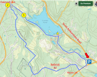
Trailhead: Westminster: Across from Wachusett Brewery off route 2A, near South Ashburnham Road. https://maps.app.goo.gl/9qzN2JHTRKLZptmN6
Hike Description: Walk out along the Whitmanville River on a small marked trail to Crocker Pond. Continue on bike trails and then a railroad line to the Midstate Trail Grafitti Bridge on Oakmont Ave. Follow the Midstate Trail and then Bathrick Road back to the start.
Hike Details: From the parking lot, walk down a gravel lane way to the soccer field, and exit the field to the right. There is a small sign for the Whitmanville River Trail. Follow the white blazes north along the river to the Crocker Pond area.
Follow the trails that keep to the west (left) of Crocker Pond. There is a small high overlook of the pond along this way. A trail to the right then leads to the western shore of Crocker Pond. Note that there are a lot of informal trails going through this area, so avoid taking the trails either to the right of the pond or back left toward the start of the hike!!
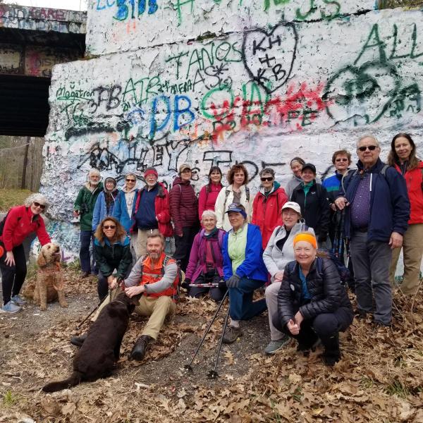
Continue on small winding bike trails along the west side of the pond and eventually the trail will take a sharp turn back and up to the railroad tracks (point #1). Turn right on the tracks and walk less than a quarter mile to the bridge over Oakmont Ave (point #2). You can descend from the bridge on either side of the road. Check out both sides of the bridge, well known as a Midstate Trail landmark for the graffiti that gets added regularly!
From this point follow the Midstate trail back to the west of the bridge and then left into the woods. At this point, follow the Midstate Trail nearly two miles through the woods. The trail passes through a cow field (remember to close the gates) and eventually arrives at paved Bathrick Road.
Descend quiet Bathrick Road for a mile back to route 2A, and then it is a short walk back to the parking area.
Other Options to Consider:
There are many trails around the south end of Crocker Pond, including trails over to the swimming area and the dam. These areas are worth exploring.
Also, it is possible to loop from the south end of the pond back to the west on unmarked trails. This loop will return to the main trail not far from the soccer field, making a shorter 2 or 3 mile loop.
The Bathrick Road walk is enjoyable to many people because it is all downhill and the road is quiet. But a car can also be dropped at the point where the Midstate Trail comes out, to make this a 4.5 mile hike.
Rev 1/24