

Wachusett Reservoir Northwest
HIKE NAME: Sterling - Wachusett Reservoir NW DISTANCE: 4.3 Miles DIFFICULTY: Easy
Restrictions: No dogs or bikes, No motorized vehicles
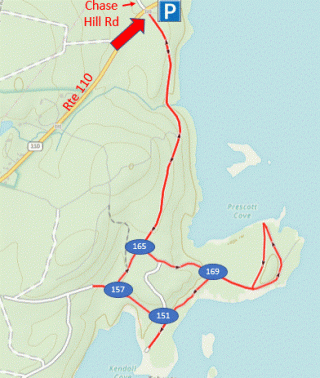
Trailhead: Sterling, Gate 35, which is close to the intersection of Chace Hill Road and Route 110. A ten-car parking area is found just north of the Chace Hill Road entrance. https://maps.app.goo.gl/FXAw6uEZyZGUWW617
Hike Description: Walk down wide gravel roads to two points on the northwest shore of Wachusett Reservoir. Walk along the shore and back through the woods. Eagles may be sighted on the islands between the two peninsulas. DCR trail markers may be used for reference, however a GPS is recommended as there are many internal roads in this area. Total elevation is 500 feet.
Links: Wachusett Reservoir Roads and Gates Map
Hike Details:
Cross the road and enter through Gate 35, which is slightly south of the parking area. Hike down the gravel road to the intersection marked with #65 (intersections are marked by DCR with signs in trees).
Bear left and proceed to Greenhalge Point, which has a nice view up toward the Clinton Dam.
Follow the trail back to point #169 and turn left to walk along the shore to point #151. Look for the eagle nest in the pine trees on the island just off the shore.
Continue along the shore to point #157, then take a right and return to the parking area.
Other Options to Consider:
From point #157 there are many trails that can be taken to extend the hike, if desired. The extensive road system provides many options, however the woods are very open, and it is easy to bushwack to the back/right of the trees that line the reservoir perimeter, and this can be done back to the south to connect to another road further down (marker #148, see DCR map in link)
Historical Notes:
The Wachusett Reservoir was built between 1900 and 1910 to serve as a water supply for the city of Boston. Water is dammed in Clinton and fed to Boston through a series of aqueducts.
The reservoir displaced the town of West Boylston, which was originally centered around the Old Stone Church that stands just across the reservoir from the Route 12 parking area.
Rev 1/24
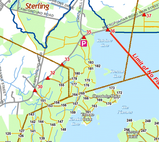
DCR Map showing the Northwest Roads and markers near Gate 35