

Rutland-Barre Central MA Trail Trail
HIKE NAME: Rutland-Barre Central Mass Rail Trail DISTANCE: 4-8 Miles DIFFICULTY: Easy
Restrictions: No motorized vehicles
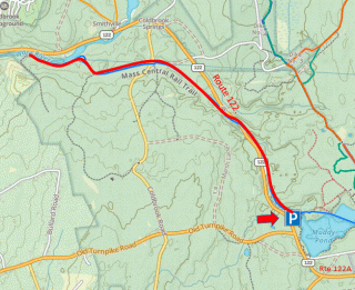
Trailhead: Rutland: Large gravel parking lot off Route 122, 0.6 miles north of the intersection with Route 122A, just north of Whitehall Road. https://maps.app.goo.gl/UCXAQCngge8ZcsNK9
Hike Description: This is an easy walk along the Central Mass Rail Trail, passing by some large ponds and streams. It crosses Route 122 and, if followed for the full four miles out, ends up at the Quabbin distribution facility on the Ware River. The length of the hike is variable, and it can be done as a one-way or an out0-and-back hike.
Hike Details: From the parking lot, take a trail from the north corner down to the rail trail and head north. This wide trail trail goes by some wetlands and streams, and crosses route 122.
Continue of the rail trail for as long as desired, perhaps up four miles to the Quabbin distribution building, where Quabbin water is controlled and sent on the the Wachusett Reservoir and Boston.
Turn around and return to the parking lot.
Other Options to Consider:
There are a number of side trails that can be explored. The CMRT also goes east from the parking lot for several miles back to Glenwood Road on the east side of Rutland. This whole trail is great for hiking, biking, or skiing.
Rev 1/24