

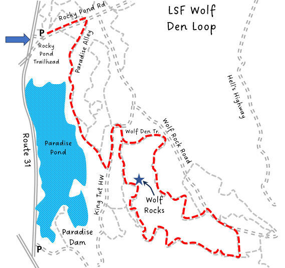
LSF Wolf Den Loop
HIKE NAME: LSF Wolf Den Loop DISTANCE: 4 Miles DIFFICULTY: Easy
Restrictions: No motorized vehicles. Hiking, trail bikes, x-country skiing and dogs are allowed
Trailhead: Princeton. Park at the Rocky Pond parking area of Leominster State Forest along the east side of Rt. 31. https://goo.gl/maps/i4XVR6Y9g8su7Rfj6
Hike Description: This is a loop that follows both gravel roads and woodland trails and brings you past Paradise Pond to the extensive rocky cliffs called Wolf Den Hill. It explores the area to the south of Wolf Den Hill, an extension of the cliffs and ledges. Total elevation gain is 300 feet.
Links: LSF Trail Map
Hike Details: From the Rocky Pond parking area take the gravel Rocky Pond road to Paradise Alley on your right.
Paradise Alley follows along the east side of the pond. There are numerous side access points to the pond. Paradise Alley ends at King Tut’s Highway.
Turn left onto King Tut’s highway, another dirt and gravel road. Follow King Tut’s Highway up the hill and there will be a small trail on the right with signage for Wolf Den Trail. Take that right onto Wolf Den Trail. The trail will split, with Wolf Den Trail (left) going up and over the ledges, and the other (right) walking along the bottom of the ledges. Stay on Wolf Den Trail to the left. This trail climbs and curves through the woods, ending at Wolf Rock Road.
Turn right onto Wolf Rock Rd. to a trail on the right, informally marked “2149” with spray paint. Take this trail due south through the woods until you reach a trail that heads to your right andis marked with pink trail markers. Turn right and follow the pink trail markers. This trail will take you up and down the rocky outcroppings and cliffs that extend from Wolf Den Hill, eventually bringing you to the base of Wolf Den Hill and, ultimately, back to King Tut’s Highway.
From there you can go left to return to the parking area via Paradise Alley, or turn right, taking King Tut’s Highway out to Wolf Rock Road, turning left onto Wolf Rock Road and Rocky Pond Road back to the parking area.
Due to the many small trails in this area, it is recommended to use a phone GPS app to watch where you are going!*
Other Options to Consider:
The Wolf Den area can also be accessed from a small parking lot on Rt. 31, just north of the intersection of Rt. 140 and Rt. 31. From the parking area follow the trail along the southern edge of Paradise Pond, over the bridge and over an odd astroturf spillway. Follow this trail until it ends at Old Country Road. Turn left onto Old Country Road until it intersects with King Tut’s Highway on the left. Turn left onto King Tut’s Highway, over a small bridge and up a slight rocky rise in the gravel road. Shortly after this rise is a small, poorly marked trail to the right (there is a sign for King Tut’s Highway on the left directly across from this small trail). Take the trail to the right that will bring you to the base of Wolf Rock Hill. If you miss this small trail, just continue on King Tut’s Highway and it will intersect with Wolf Den Trail..
Historical Notes:
Rev 1/12
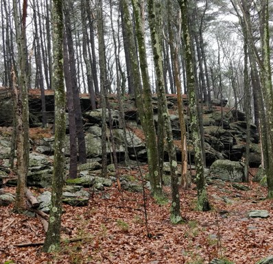
The trail at Wolf Den Hill runs both below and over the rocky outcrop