

Holden Rail Trail Off-Trail
HIKE NAME: Holden Rail Trail Off-Trail DISTANCE: 3-7 Miles DIFFICULTY: Easy
Restrictions: No motorized vehicles, No bike or dogs
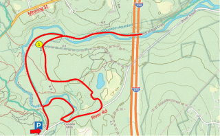
Trailhead: Holden: River Road, at the parking area for the Central Mass Rail Trail. https://maps.app.goo.gl/Mc3JHezqSWNAjzaZA
Hike Description: An easy hike on the Central Mass Rail Trail and other smaller trails to the west of the rail trail.
Hike Details: Walk past the gate and down the Rail Trail. Before the bridge over the Quinapoxit River, turn right on a small trail and follow this trail along the river in a winding route until returning to River Street.
Walk up River Street, bearing left. This goes uphill and around a steep hill before reaching a gate in a more open area. Turn left and go through the gate, following this small path until the next intersection. Turn left and then bear right at the following intersection to return to the Rail Trail. Along this path you will cross the Quabbin Aqueduct (point 1) which is not marked.
Walk the Rail Trail for as long as you desire, past the Stillwater Mill exhibit to the I290 overpass. Then return using the Rail Trail.
Other Options to Consider:
The hike length can be as long as you choose as the Rail Trail runs all the way into West Boylston. There are also many pretty small trails to explore on the west side of the Rail Trail.
Also there is a nice option to walk along the abandoned River Road (Holden)/Thomas Road (West Boylston) down to route 140, returning on the Rail Trail.
Because of the number of options, a GPS is a useful tool for exploring the many options.
Rev 1/24