

Sterling - Hog Hill
HIKE NAME: Sterling - Hog Hill Loop DISTANCE: 3 Miles DIFFICULTY: Easy-Moderate
Restrictions: DCR Watershed. No dogs, bikes, or horses
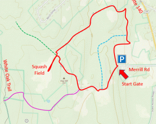
Trailhead: Sterling. Take 140 South from Princeton, and turn right on Merrill Road (shortly before Sterling Greenery). Parking is located at the end of the road. https://maps.app.goo.gl/jhzUSNspDsrW3Gc6A
Hike Description: Hog Hill is a DCR property with a gate at the end of Merrill Road in Sterling. The property includes woodlands, forest and open fields along with some ruins of the Kristoff Pig Farm. The loop is a pleasant walk through old farm roads, with an especially pretty walk around the top and back of Hog Hill. Total elevation is 150 feet.
Links: Sterling Brochure; History of the Kristoff Pig Farm
Hike Details:
From the end of Merrill Road, go through the gate and up to the top of Hog Hill. Ruins of the garbage ‘cooker’ can be seen at this point, and there are some pretty open fields around the trail. There is a trail that goes straight at this point (purple line on map - see Options to Consider).
However, for our hike, take a right in back of the cooker ruins along the top of Hog Hill and down a pleasant farm road. This continues downhill and turns sharply right. Follow this trail to the right, but before walking down the road, explore the short path to the left, which goes out to a small wetland that was the squash garden in the pig farm days.
Back to the main trail, proceed down the hill past a couple of large open fields. The road turns sharply left and then right. Take this path to the right back through a pine stand and toward Merrill Road. Return to Merrill Road through the border of the fields. The field may be uncomfortably high in the summer, and in that case you may prefer to retrace your steps around the loop. This can be determined from the parking area at the beginning of the hike.
Note that there is an informal trail through the woods on the right just before you reach the field (blue dotted line on map), however this is often hard to find. If it is marked and usable, it goes up the hill and back near the start of the hike, and avoids a more difficult trudge through the field.
Other Options to Consider:
The path that extends straight past the cooker winds through the woods, along a stone wall and then through to Trout Brook Conservation Area in Holden (purple line on map, to White Oak Trail). This is marked 'No Trespassing' on the sides of the trail but the owner allows hikers to pass through to Trout Brook.
In addition, from the corner by the squash field it is possible to go north (green dotted line on map), and this smaller trail winds its way to Holden Road in Sterling, near the entrance to Poutwater Pond. However this trail is questionable.
Historical Notes:
Sterling has a good deal of information about the Kristoff Farm, which was at one time the largest provider of Virginia Ham in the world. A summary of this information can be found on the Sterling trail brochure (see link above).
Rev 1/24
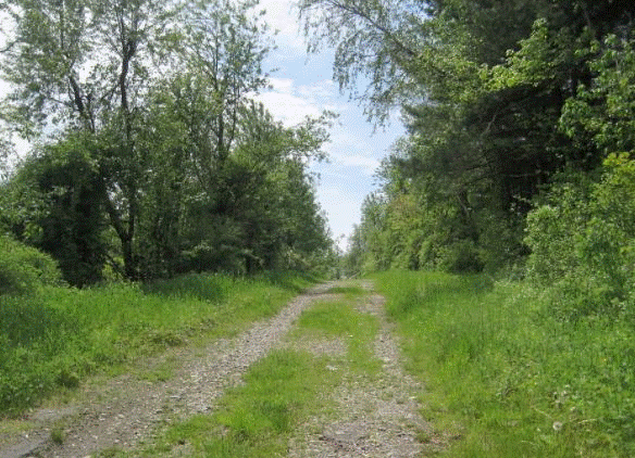
Pretty gravel trails through over Hog Hill

2018 Hikers by the Squash Patch