

Wachusett West Loop
HIKE NAME: Wachusett West Loop DISTANCE: 4.5 miles DIFFICULTY: Moderate
Restrictions: Dogs leashed only. No Horses or Bikes on trails
Trail Description: This loop goes about halfway up the mountain on gradually inclined gravel, roads and trails. It does not go to the summit, but there is a nice view from the North Road on the way down. 790 feet of elevation gain.
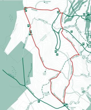
Trailhead: The gate at the intersection of Westminster Road and Administration Road (about one mile up Westminster Road from Mountain Road). Park along Westminster Road. https://goo.gl/maps/NQJWHCQ2zfGfLBHn7
Hike Details:
From the parking area on Westminster Road proceed up Administration Road to Jack Frost Trail. This section of the trail goes through close laurel bushes which can be pretty in June.
Shortly after starting on Jack Frost, take a left onto the Lower Link Trail, and then a right when it intersects with Harrington Trail (the Midstate trail). This area can be wet in the spring.
At the top of the second little hill, take a left on Semuhenna Trail and follow it along the shoulder of the mountain and then over the paved ‘up road’, past the West Side Trail then out to the paved road, near North Road. This second section of Semuhenna can be muddy and can best be navigated to the right side. Go to the left on the paved ‘Up road’, and then turn right onto North Road.
Take North Road down to a vista (great place for photos) and continue on North Road to West Princeton Rd (Westminster). North Road is a pretty gravel road with some areas of pine needles. There is a kiosk where the North Road hits West Princeton Road.
Take a left on West Princeton Road and then, in a half mile, another left through the gate onto on West Road. West Road has some slight elevation changes, but is otherwise a pleasant gravel road. There is a small ‘Siplas Pool’ (so named for a local resident) a hundred feet or so off the trail. Also on the north side of the west road, shortly after leaving West Princeton Road, there are some nice ice ledges about 200 yards up at the (steep) embankment. These have lovely icicles in the winter and are worth a bushwack!
After close to a mile on West Road, turn right onto the Harrington Trail and then take Stagecoach Trail left up past the windmills and back to the parking area. There is a nice view from the huge windmills area…this is a spot to check out!!
Other Options to Consider:
Echo Lake can be added to the start or end of this hike. It is a one mile loop from Administration Road, normally using Echo Lake Road for one direction and Echo Lake Trail (from Westminster Road) for the other direction. Consider stopping at Mountainside Cafe, a short walk from Echo Lake.
When you reach the paved road near North Road, consider taking a short walk to the right and crossing the west-side ski trails. There is a view to the north from the ski trails.
A summit run can also be added. This adds a mile but also another 400 feet of climb, continuing past Semuhenna up Harrington Trail, and returning down Old Indian Trail to West Side Trail to Semuhenna.
Rev 1/24
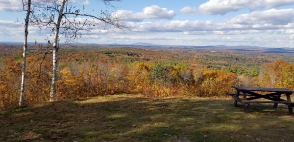
The view from the North Road Lookout, north to Mount Monadnock
North Road Lookout, with views to Mount Monadnock