

Thomas Prince Nature Trails
HIKE NAME: Thomas Prince Nature Trail Loop DISTANCE: 2 Miles DIFFICULTY: Easy
Restrictions: Non-Motorized traffic only. Trails are not open during school hours.
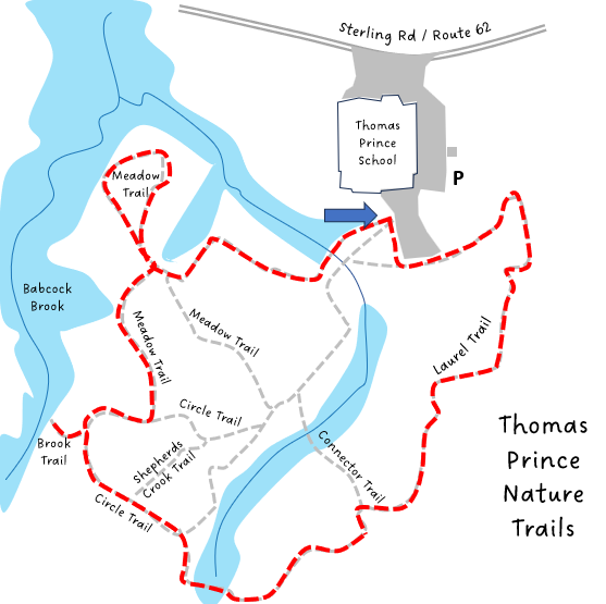
Trailhead: Park at the Thomas Prince School (TPS) parking lot off Route 62 east of Princeton. The Laurel Trail (recommended route) starting point is across the field to the left when facing the back of the property. https://goo.gl/maps/7RmArbYcuypVN27v9
Description:
This is an easy and relatively flat walk through the town properties behind Thomas Prince School. Students use this area for various activities during the school year. The route described below is a loop around the furthest extent of the property, with a short spur walk down to Babcock Brook. The route goes through laurel bushes, open forest, and a field that is growing back into forest.
Links: TPS Kiosk
Hike Details:
Walk over to the right of the playground to check out the kiosk and trail map that were designed by TPS students.
Reverse direction and follow the line of the woods behind the ball field to the start of the Laurel Trail, and follow it through a large stand of mountain laurel. The laurel blooms in June and can be a beautiful area! It is also pretty in the winter after a snowfall.
The Laurel path continues and some connector trails branch out to the right, but keep to the left until it intersects with the Circle Trail.
Follow the Circle Trail to the Brook Trail, and take a short walk to the left to check out Babcock Brook. Return to the Circle Trail and take a left.
Follow the Circle Trail until it intersects with the Meadow Trail, and then turn left to follow the Meadow trail around the Meadow loop, then return, bearing left along the side of the large soccer field to the TPS parking lot.
Note: Work is in the planning stage to rebuild the paths near the kiosk with a more accessible trail, and to replace the bridge structures.
Other Options to Consider:
The trails can also be accessed from the kiosk, following a variety of courses.
Follow one of the smaller trails to create a shorter or longer hike. The route can also be reversed to get a different perspective to the area.
There are also a number of passageways in the Meadow that are not on the map, but are worth exploring.
Historical Notes:
The nature trails were the vision of a TPS science teacher, Joanne Blum, and were developed under her direction with a great deal of help from school, town, and Mass Audubon volunteers. Mass Audubon continues to help with trail maintenance.
Rev 1/24