

Red Fox Farm Trails
HIKE NAME: Red Fox Farm Trails DISTANCE: 1.5 Miles DIFFICULTY: Easy
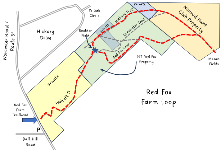
Trailhead: Princeton. Park at the corner of Ball Hill Road and Worcester Road (Route 31). The trailhead is on the east side of the road just north of the junction.
Hike Description: This is a flat walk that crosses two wetland areas on private land before entering Princeton Land Trust’s Red Fox property. The trail loops south along the property boundary before turning north and then west to complete the loop back. Spur trails connect to trails owned by the Nimrod Hunt Club, which are open for public use. Total elevation of the Red Fox trails is 100 feet.
Links: (None)
Hike Details:
Enter the Red Fox property through the stone wall and follow the trail through the field and around a pine stand.
Cross the wetland and turn right to continue on the trail. This leads to a second wet area with a bridge. Keep to the right to skirt the wetland on the far shore then proceed leftward for a short while until the trail leaves private land and heads into PLT property..
The trail then proceeds to a rocky outcrop, where the loop splits. Follow the trail to the right out to the stone wall separating PLT Red Fox property from DCR property. Follow this until a wider, more established trail is encountered, and then turn back to the left to continue around the loop (or to the right to continue out to thru Nimrod land to the Mason Field.
Other Options to Consider:
Spur trails to the southeast lead through Nimrod and then DCR property down to Mason Road, which is 2.5 miles from the trailhead. This trail goes through a high meadow with some views, and is very pretty in the fall and winter. The field is often quite wet in the spring and may now be mowed until later in the summer.
Also, it is a short (less than .25 mile) walk down Mason Road to the junction with Sterling Road (in Holden). Turn right or left at this junction to find one of two trail heads for Trout Brook Conservation Area can be reached in less than a quarter mile. The distance from the Red For Farm Trailhead through Trout Brook to Manning Street is 4.5 miles, and to the River Road parking area of the Central Mass Rail Trail is 5.5 miles, and via the CMRT to Oakdale is about 7.5 miles. This makes for a nice, mostly downhill, one way hike from Princeton to Holden or West Boylston.
Nimrod has other trails that connect to Coal Kiln Road and back via DCR land to the Princeton Land Trust Russell Corner area. These areas have been left undocumented at the request of the property owners, but hikers are welcome to explore.
Rev. 12/4/2023