

Leominster State Forest Hillbilly Heaven
HIKE NAME: Leominster State Forest Hillbilly Heaven Trail DISTANCE: 4.5 Miles Difficulty: Easy
Restrictions: No motorized vehicles. Trail bikes and dogs are allowed in Leominster State Forest.
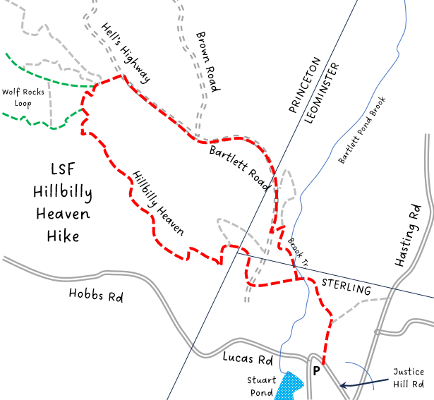
Trailhead: Sterling. Take 140 North toward East Princeton, and turn right onto Leominster Road just before East Princeton Village. Follow the road about a mile and turn left after the pond onto Lucas Rd. Turn right at the turn to go up Justice Hill Road for a hundred feet or so. Park at the Justice Hill Trailhead gate. Please do not block the gate. https://goo.gl/maps/soxFL3sYR1GB28xz9
Description: This area in the southeast section of Leominster State Forest is an interesting level hike through the woods. The trails are mainly maintained by the local mountain biking club and lack blazes and signage. The loop has a number of small ups and downs passing by several bodies of water.
Links: Leominster State Forest Map on Trailforks
Hike Details:
Enter through the gate and follow the trail, bearing left at two small trail intersections, up to its intersection with Bartlett Road.
Hillbilly Heaven is straight across and is a well-used, but little marked foot trail through a mostly pine forest. It goes over several bridges and past water pools, but is relatively dry year-round. Follow the trail mainly uphill until you reach an intersection with a connecting trail on the left. Stay straight and continue a little further on Hillbilly Heaven which snakes its way around to the intersection with Wolf Rock Road.
Take a right onto Wolf Rock which is a gravel road and follow it a short way to the intersection with Hell’s Highway. Take a right onto Hell’s Highway and follow it until it turns into Bartlett Rd.
The Brook Trail is a small trail to the left off Bartlett Road which meanders along a pretty brook and returns to the original trail and the gate. If you miss that turn, you will end up at the Bartlett Road and Hillbilly Heaven intersection, turn left to return to the gate/
Other Options to Consider:
Just before hitting Wolf Rock Road, a small path goes off to the left and heads out to the Wolf Den rock formation, making a longer 6-7 mile loop. See green line in map. This trail is not well marked, so use of a GPS will make the hike much easier.
After reaching Wolf Rock Road, just to the right and across are two trails, Frick and Frack, which both provide short loops to the north and back to meet up with Wolf Rock.
Historical Notes:
Rev 1/24

Princeton Hikers on Hillbilly Heaven Trail