

Wachusett Redline
HIKE NAME: Wachusett Redline Hike DISTANCE: 17.5 Miles DIFFICULTY: Very Difficult
Restrictions: No motorized vehicles, No bikes
Trailhead: Princeton. Westminster Road / Administration Road trailhead, which is about 1 mile up Westminster Road from Mountain Road. https://goo.gl/maps/KJdDtXXXSpmCw73N8
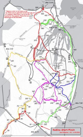
Hike Description: The Wachusett Redline hike is a 17.6 mile hike that completes all trails on the Mountain (not including the roads). The route presented involves over 4,400 vertical feet of hiking, and is normally done in between 7.5 and 10 hours.
This hike can be done in a single day or over multiple days. Both one-day and four-day versions of the hike are shown below.
Hike Details:
The map and steps documents provided for the one-day hike (above) show one way to complete the redline walk in a single day, minimizing the number of redundant steps and arriving back at the starting point. The table shows a way to do it in four days, with four hikes that each start and end at the same place. The redline can be completed in many ways, over any amount of time, but a record must be kept of date for each trail in order to get a patch..
The Wachusett Hikers Facebook Page has more information about this hike and hiker comments.
People completing this hike may apply for a patch by filling out the application form and sending it in.
Due to the length of the hike, consider caching water and other supplies along the way.
Rev 1/24

Links to maps and step-by-step instructions:
| One Day Route | Map | Step-By Step Guide |
| Map | Step-by-Step |
|---|---|
| Day 1 Map | Day 1 Steps |
| Day 2 Map | Day 2 Steps |
| Day 3 Map | Day 3 Steps |
| Day 4 Map | Day 4 Steps |