

Wachusett North Loop
HIKE NAME: Wachusett North Loop DISTANCE: 5 Miles DIFFICULTY: Difficult
Restrictions: Dogs must be leashed. No bikes or horses.
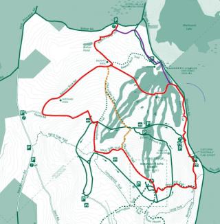
Trailhead: Bolton Pond Trailhead, which is off Bolton Pond Road, just west of the entrance to the ski area. https://goo.gl/maps/gyn63vpk2EoQV3H76
Hike Description: This is a difficult hike from the north side of the mountain, past Bolton Pond, Balance Rock, and the North Road lookout to the summit. The return is via Pine Hill and Donbrowo Trails, and then across Balance Rock Road. Elevation gain is 1200 feet in total. There are several alternate hikes available including a shorter route that goes halfway to the summit.
Links: Full Wachusett Mountain Map
Hike Details:
From the Bolton Pond trailhead, climb up and bear right on Bolton Pond Trail. This drops down to follow a pretty brook and then passes Bolton Pond, a small beaver pond on the right.
Continue on Bolton Pond Trail through an often-muddy section and ascend up to and past Balance Rock, a great photo spot. The path can be difficult to follow up this section…watch for the blue markers.
Shortly past Balance Rock take a right onto Balance Rock Road, a wide gravel road that gradually ascends up to North Road, and is very pretty, particularly in the fall. This goes past the Needham Pool.
Take a left on North Road and ascend to the North Road Lookout, which has a great view off to the north to Mount Monadnock. The Wapack Range is also visible to the right of Monadnock, and Gap and Little Wachusett mountains are visible to the left.
Bear left on the paved road and then take Semuhenna trail off to the right.This middle section of Semuhenna goes through a pine grove and can be quite pretty but also wet in places.
Just before Semuhenna hits the paved road again, take a left onto the West Side Trail to cross over to the Old Indian Trail.
Take a right on Old Indian Trail onto a steep and rocky path, and follow it to the summit. Enjoy the 360 degree views from Wachusett Summit, and spend some time checking out the surrounding peaks and features from the maps in each direction from on top of the viewing platform.
To descend, start down the paved road and take a left onto the Pine Hill Trail. This is a steep, well maintained trail with many steps, and can be slippery in fall and winter.Follow Pine Hill Trail to the Visitors Center, where visitors can learn about the mountain flora and fauna, and geological history.
Continue from the Visitor Center down to the gate area, and take a right through the fence to the Donbrowo Trail. Descend on Donbrowo,passing an old cellar hole (the Roper Homestead) just off to the left about halfway down, to the ski area.
Take a left onto Balance Rock Road and follow it back to Balance Rock Trail. Balance Rock Road is a pretty road that provides some nice lower level overlooks and passes by the Bullock Lodge.
Return on Balance Rock Road to Balance Rock Trail, and then take Bolton Pond Trail to the left, just past Balance Rock.
Other Options to Consider
When the ski area is operating, bypass Balance Rock Road at the end, and continue from Donbrowo Trail down to the ski area parking lot. Turn left and follow the edge of the lot to the back end, near the maintenance buildings. A small trail from the back corner will take you back to Bolton Pond Trail (purple line on the map, above). This is also a shorter way back!
A shorter way to hike up the north side is to take Balance Rock Trail to Old Indian Trail, and either take that or Semuhenna Trail up toward the summit. The Balance Rock Trailhead is in the Wachusett Ski Area parking lot, and is a popular place to start the hike when the ski area is closed. These routes are not as scenic. Old Indian Trail does cross the ski trails and so should be avoided during ski season.
There are also options to shorten the hike by using the paved roads. A much shorter, easier, and less crowded walk can be accomplished by bearing left at the top of the North Road and following the ‘up road’ down to the gate, then proceeding on Donbrowo Trail. Princeton Hikes has used this route during the busy Columbus Day weekend, to avoid the crowds. This way does not go to the summit, but does have nice views from the North Road lookout and over the ski trails.
Another option is to walk the ‘down’ road from the summit, passing by the Hartlow Outlook, which is a pretty spot to have lunch or to view sun rises and moon rises, with a great look out to the east and the skyline of Boston.
Rev 1/24
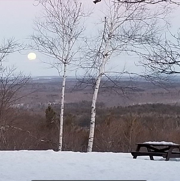
Wachusett North Road Lookout at Moonset
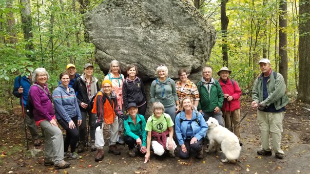
Princeton Hikes at Balance Rock