

Mill Street Rail Trail (Holden)
HIKE NAME: Mill Street Rail Trail DISTANCE: 4.5 Miles DIFFICULTY: Easy/Moderate
Restrictions: No motorized vehicles. Dogs are not allowed on DCR wetlands property but bikes are allowed.
Trailhead: Holden. Mill Street, just west of Route 31. Turn into the North end of Mill Street from Route 31 and drive about a quarter mile south to a parking lot on the right. https://maps.app.goo.gl/Z9eP8o3S5joQAJHN6
Hike Description: This DCR property has several very nice trails including a newly finished two mile stretch of the Central Mass Rail Trail (CMRT). These are labeled as 'Bike Trails' on some maps. The hike goes to the west end of the rail trail and then parallel to the train tracks to Princeton Street, returning to the rail trail.
The hike then takes smaller and more scenic trails to the south of the rail trail, along Asnebumskit Brook. The exit goes down to Mill Street and past a waterfall at an abandoned mill site. Total elevation is 500 feet for this hike.
Links: None
Hike Details:
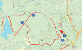
Walk up the long curving entrance ramp to the rail trail and turn right. Follow this Rail Trail about two miles to a spot where the finished trail turns right (past Point A on map). Go straight on the unfinished portion of the rail trail, to the end of the rail trail, at a discontinued bridge abutment..
Reverse direction and hike a short distance to where a large trail goes left (north). This becomes a small trail that goes parallel to the train track. The path goes into the woods and then exits onto a gravel road. Turn right on the gravel road and follow it back to the finished rail trail (Point A), turning right to rejoin the CMRT.
Follow this to the spot where the rail trail bears left and the old rail bed goes right. Follow the old bed right shortly until a well-used trail goes to the left (Point B). Take this trail which goes to the southern trails in the area. Continue on these well-used trails around the south side of the area, eventually following the Asnebumskit River on a high esker, until the trail returns to the mail rail trail.
Continue across the rail trail and back down the long entry ramp to the parking lot.
Other Options to Consider:
An easier hike involves staying on the rail trail for the entire distance, as an out-and-back hike. The trail is well-maintained and flat, but not very scenic.
At the end of the hike, consider going right (south) on the rail trail, away from the entrance ramp (Point C on the map). This leads down to the bridge over the Asnebumskit Brook, and a trail on the north side of the brook can be used to walk to Mill Street. Turn left on Mill St. to return to the parking area.
There are a number of other trails on the south side that can make for interesting options.
Historical Notes:
Rev 1/24

2020 Princeton Hike on the Quinapoxet Rail Trail