

Princeton Land Trust: Krashes to Russell Corner Loop
HIKE NAME: PLT Krashes to Russell Corner Loop DISTANCE 3.6 Miles DIFFICULTY: Moderate
Restrictions: No motorized vehicles
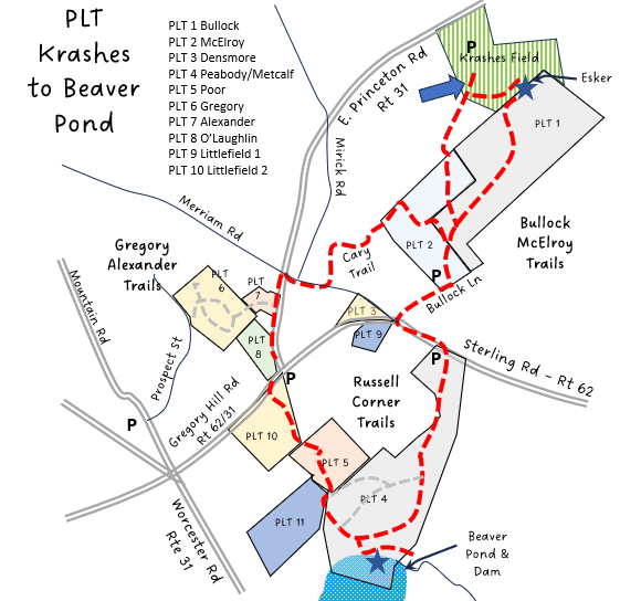
Trailhead: Princeton. Krashes Field parking area. Follow hiking signs to the walking track and then over to the Kiosk. Alternatively the hike can be started at Bullock Lane or at the Russell Corner parking lot on route 62.https://goo.gl/maps/crsohVvQqFDB4fZcA
Hike Description: This hike loops around the Bullock-McElroy Princeton Land Trust (PLT) property and then goes across route 62 to tour the Russell Corner Trail area, including the beaver pond at the south end of the property. It passes over the high esker next to Krashes field and goes through the Hall Field, which has a fine view of Princeton Center. Total elevation is 450 feet.
Links: None
Hike Details:
From the kiosk at Krashes Field, follow the path up the hill to hit the Bullock-McElroy Loop Trail. Take a left and work through the woods and climb the steep side of the Esker. Turn left at the top of the esker to check the view at the end, and then reverse direction and follow the trail along the top of the esker, down past the bowl to the forest floor..
Continue on the loop trail through the woods, bearing left at the intersection with the Connector Trail, and then out to the open Bullock field. and Continue through the field to the second kiosk and Bullock Lane. Follow Bullock Lane to Route 62 (Sterling Road) and turn left, then walk down to the Princeton Land Trust Russell Corner parking lot, where a kiosk for that area will be found.
Continue on the Peabody-Metcalf Trail into a new growth forest and then down through the woods to a large open beaver pond with an overlook (Jones Meadow). This is a good spot for birding.
Reversing direction from the overlook, find the trail to the right that heads down to the east end of the pond, to view the beaver dam. This trail can be wet near the dam. Also visible on this side of the pond are some very impressive stone walls, reputedly built by captive British (Scotch-Irish?) soldiers during the revolutionary war.
Return to the main path and turn right to continue on the loop. Instead of continuing on the Peabody-Metcalf Loop at the next intersection, bear left and follow the trails out to the Hall Fields, with pretty views up to Princeton Center.
Cross the fields (these are active hay fields, so stay to the edge near the wall), and exit at the intersection of Route 31/East Princeton Road and Route 62/Gregory Hill Road.
Walk along East Princeton Road to the North (go straight when exiting the field) and then turn right on Merriam Road.
From Merriam, turn left at the edge of the horse field just past Mirick Road, and turn left onto the Cary Trail. Follow the Cary trail through the woods back to the Bullock-McElroy Field Loop trail.
Turn left to cross the field, and at the end, bear left to take the westerly side of the loop back to Krashes Field.
Other Options to Consider:
The ‘Central Princeton Loop’ is a five mile trail that visits all three of the Princeton Land Trust properties in the area using the connections to PLT Gregory-Alexander and PLT Bullock-McElroy.
The total hike can be shortened by taking a right from the Peabody-Metcalf trail and following the Poor Family Trail down to Hall Field.
Consider starting the loop at other Parking areas around the PLT properties.
Historical Notes:
The large walls on the east side of Jones Meadow are very impressive, and local legend suggests that they may have been built by captured enemy soldiers working in the area after the battle of Ticonderoga in the Revolutionary war.
The Esker out by Krashes Field, along with other glacial ‘bowls’ is worth noting. The esker and bowls were created about 20,000 years ago when the glaciers plowed through the region. The ice was a mile or two thick at that time.
Rev 1/24
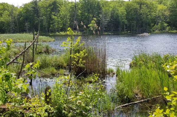
The Jones Meadow Overlook