

Leominster - Monoosnoc to Sholan Farms
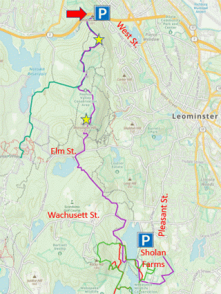
HIKE NAME: Leominster - Monoosnoc to Sholan Farms DISTANCE: 7 Miles DIFFICULTY: Difficult
Restrictions: No motorized vehicles
Trailhead: Leominster. End of West Road. Take Merriam or Abbott Road off of Route 2, then to Liddell Ave, and then to West Road. There is a parking lot and kiosk at the end. https://maps.app.goo.gl/EEavVde7DyExxpAQ6
Hike Description:
Hiking the Length of the Monoosnoc Trail from North to South is a longer hike but the path is a really nice trail over the Monoosnoc Ridge, with two nice lookouts along the way. It starts near Route 2 and goes through Leominster, ending by the Fall Brook Reservoir at Sholan Farms…a great destination during apple-picking season! The trail is well marked throughout with blue blazes...however note that the short loop to the South Monoosnoc view is not blazed.
There are some sections of the trail that follow old roads and can be wet at times, but most of the trail is dry and nice for walking. There are some steep sections at the start and on the way down South Monoosnoc.
The Leominster Trail Stewards have done a great job of locating map signs at key junctions and these are very useful to monitor progress through the hike.
Total elevation is 1,200 feet.
Links: Monoosnoc Trails Page
Hike Details:
For this hike, meet at Sholan Farms and drop cars, then carpool through Leominster to the West Road Trailhead.
The trail starts uphill for the first half mile. This is the most difficult part of the hike, and can be quite icy in the winter. After walking around the water tower and up the hill along an often wet stream bed the trail reaches the first viewpoint, which is a wide ledge looking to the east over Leominster and along route 2. This is the best view of the hike!
The trail proceeds over North Monoosnoc Hill and along the ridge to South Monoosnoc. There is a small side trail to the right that goes over to South Monoosnoc (not shown on the map), and this is definitely worth the diversion as there is a second pretty view out to the west and Mt. Wachusett. This is a short loop that reconnects with the main trail. Make sure to watch for and take this side trail (see yellow stars on the map).
Continue along the trail, descending off the ridge steeply and then crossing Elm Street and Wachusett Street and then enter the Fall Brook reservoir area. The trail then goes around Fall Brook Reservoir and through an open field, then around an apple orchard and back to the Sholan Farms parking lot.
Other Options to Consider:
Hiking south to north is another option, but may feel like it is more uphill than going the other way.
There are numerous options around the Monoosnoc main trail, on both the east and west sides, and there are also options down around Fall Brook Reservoir. Also it is easy to break this hike into smaller sections, for example to hike from the trailhead to South Monoosnoc and back.
Historical Notes:
Rev 1/24
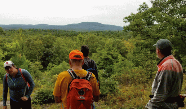
The view from South Monoosnoc

Hikers at the North Monoosnoc Overlook