

Leominster State Forest Paradise Pond and Wolf Rock Loop
HIKE NAME: LSF Paradise Pond Loop DISTANCE: 4 Miles DIFFICULTY: Easy
Restrictions: No motorized vehicles., Hhiking, trail bikes, x-country skiing and dogs are allowed
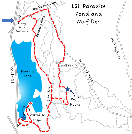
Trailhead: Princeton. Park at the Rocky Pond parking area of Leominster State Forest along the east side of Rt. 31. https://goo.gl/maps/VmKtCUkyvcgKZ9QE6
Hike Description: This is a loop that follows both gravel roads and woodland trails bringing you past Paradise Pond and down to the dam on the south end. On return, the hike passes over the Wolf Den rocky outcrop. Total elevation gain is 300 feet.
Links: LSF Trail Map
Hike Details: From the Rocky Pond parking area take the gravel Rocky Pond road to Paradise Alley on your right.
Paradise Alley follows along the east side of the pond. There are numerous side access points to the pond. Paradise Alley continues uphill and ends at King Tut’s Highway.
Turn right onto King Tut’s highway, another dirt and gravel road. Follow this to Old County Road and bear right to head to the south end of Paradise Pond. Bear right again at the bottom of the hill to pass over a small hill and walk across the dam, a very pretty spot!
Continue past the dam and follow the trail sharply left, returning to Old County Road. Retrace steps up to King Tut’s HIghway and turn left.
Follow King Tut’s Highway up the hill and there will be a small trail on the right.This trail is poorly marked, though there is a sign directly across from the trail identifying King Tut’s Highway. Take that to head over to the Wolf Rocks area. The trail will split, with one side going up and over the ledges, and the other avoiding the climb and walking along the bottom of the ledges.
When going over the ledges, stay on the west side of the hill and continue to reconnect with the split trail. Follow this down to the wide gravel road that is King Tut’s Highway.Take a right on King Tut’s Highway. It will soon intersect with Wolf Rock Road.
Turn left and follow Wolf Rock Road to Rocky Pond Road, then turn left and follow to the parking area.
Other Options to Consider:
To extend the exploration of the area and lengthen the hike, from the south end of the Wolf Den rock outcrop, take a right and follow the N.A.D.S trail out to Wolf Rock Road. Wolf Den Trail can also be taken back off the main gravel road (see map).
This hike can also be reversed, starting from the south end of Paradise Pond, a smaller parking area off route 31 near the intersection with Rte 140.
There are many trails in Leominster State Forest, though trail markings are more scarce in the south area of the forest. It is worthwhile to have a GPS app or a compass and a map.
Rev 1/24

The Laurel Bushes can be fantastic on the east side of Paradise Pond!

Princeton Hikes Group at the Paradise Pond South Dam