

Leominster State Forest Ball Hill Loop
HIKE NAME: Ball Hill Loop DISTANCE: 4.5 Miles DIFFICULTY: Moderate
Restrictions: No motorized vehicles
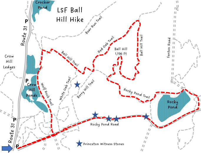
Trailhead: Princeton. Leominster State Forest, Rocky Pond Road Trailhead
Hike Description: Hike up along the pretty Crow Hill Ponds and then climb and loop around Ball Hill (no view). Continue east to loop around Rocky Pond, and return along Rocky Pond Road. There are several witness stones along the route which are interesting to check out. Total elevation is 1000 feet. https://goo.gl/maps/i4XVR6Y9g8su7Rfj6
Links: DCR Trail Map
Hike Details:
Starting at Rocky Pond Trailhead, walk out the gravel Rocky Pond Road until the intersection with Wolf RockTrail.
Turn left and follow Wolf Rock Trail past the Crow Hill Ponds and the causeway between the two ponds. Consider stopping over to the picnic area (with restrooms at times). This is also an alternate trailhead in the winter when the gates are open.
At the swim area parking lot, turn right onto Ball Hill Trail. Ascend Ball Hill. Consider bushwacking to the first witness stone near the top of Ball Hill.Red Oak Trail (see map. It is down along the stone wall, where it intersects with another stone wall, just off the Berry Hill Trail)
Turn left on Red Oak Trail and follow it to the second intersection with the Ball Hill Trail (Red Oak Trail continues straight). This is a pretty trail over the hill and through a pine forest.
Return on Ball Hill Trail along the Leominster-Westminster Line, a long stone wall, and ascend to the top of Ball Hill. Then proceed to the intersection with Rocky Pond Trail.
Turn left on Rocky Pond Trail and descend to Rocky Pond. This trail can be wet/muddy at times, and is somewhat rocky, particularly along the back of Muddy Pond. But there are some nice views of Rocky Pond.
Turn right after the pond onto Fenton Road, and then take a second right onto Parmenter / Rocky Pond Road. There is a boat launch area that can be used off Fenton Road to get to the water.
Follow the gravel Rocky Pond Road back to the starting point. Check out the witness stones along the way (on the right).
Other Options to Consider:
A slightly longer hike can be made by taking the Sawyer Run Trail out of the Rocky Pond Trailhead, which winds around the pine trees on the south end of the Crow Hill Ponds.
The hike can easily be shortened by cutting out the loop down Red Oak Trail (instead, stay on Ball Hill Trail) or cutting out Rocky Pond by taking the Limbo Trail, just before Rocky Pond.
A half mile can be added to the hike by taking the Black Bear Trail instead of the Ball Hill Trail. Then loop back via Red Oak to Ball Hill or on Fenton Road directly to Rocky Pond.
Historical Notes:
Boundary Stones, or Witness Stones: In the 1700s, Massachusetts law required towns to construct and maintain stone markers to designate boundaries with neighboring towns. This civic task, which was required to be performed regularly by elected town officials, was referred to as “perambulation.” These stones were generally placed where the town lines change orientation. In Princeton there are around 25 stones still known to exist, five of which can be seen along this route. You will notice years painted or chiseled into the stones going back to the 1800s. With a good GPS it is easy to locate the stones.
Rev 1/24
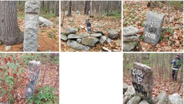
Witness Stones
GPX File (Note: Click to download, Rename to .GPX, import into your GPS hiking app).