

Leominster State Forest
Leominster State Forest (LSF) is a 4300 acre state forest, run by the Department of Recreation and Conservation. It is located in northeast Princeton and spreads into Leominster, Westminster, Fitchburg and Sterling. It has dozens of trails which are great for hiking and also biking, cross country skiing, and snowshoeing. LSF is a hunting destination as well.
LSF is on the Midstate Trail, which connects to the west over to Redemption Rock and Wachusett Mountain, and also north to Westminster, Rocky Pond, and Mount Watatic. The park also connects east to Leominster's Monoosnoc Trail and then to the Sholan Farms and Heywood Reservoir trail areas.
The land is forested with several ponds and reservoirs. Swimming is allowed at LSF Crow Hill Pond off Route 31 seasonally.. Fishing and boating are allowed on Paradise Pond, located just south of the headquarters.There are also several trailheads around the perimeter of the park. The Crow Hill Cliffs, located across from the swimming area, offer one of the best rock climbing surfaces in the area. This area is for experienced rock climbers only!
The Hikes Documentation page lists several hikes which have been done by the Princeton Hikes! group, including loops to Paradise Pond, Notown Reservoir, Ball Hill, and Crow Hill. Be aware that this is a large area,inconsistently blazed and signed, and it is easy to get turned around. Using a cellular/GPS app here is recommended!
The DCR Map of LSF shows the main trails in the park. A more complete map of trails can be found on the New England Mountain Biking (NEMBA) website.
Some of the main hiking routes are:
Parmenter Road/Rocky Pond Road, which are gravel roads connecting the east side (Rocky Pond TrailHead) with the West Side (Parmenter Trailhead) of the park. 2.5 Miles with 350 feet of elevation.
King Tut's Highway, which goes south from Rocky Pond Road down past Paradise Pond. 1.3 Miles, 130 feet of elevation.
Wolf Rock Trail, a pine-covered trail which connects Rocky Pond Road to the Swimming area. 0.7 Miles with minimal elevation.
Hell's Highway, a gravel road connecting Rocky Pond Road (near Rocky pond) with Bartlett Trail, down toward Hobbs Road. 1.5 Miles gravel Road with minimal elevation
Brooks Road, a gravel road connecting Parmenter Road (near the Parmenter lot) to Bartlett Road down by Hobbs Road. 1.6 Mils with minimal elevation.
Bartlett Gate to Bartlett Road, a trail and gravel road combination that connects the gate on Lucas Road in Sterling with Brooks Road and Hell's Highway. 1 Mile and minimal elevation.
Some Interesting features in the park include:
Crow Hill Ponds: Two connected ponds with trails on the east side. Large parking lot open in the off-season for hiking.
Crow Hill Cliffs: One of the better rock climbing areas in Massachusetts with 70 foot sheer cliffs. Trails lead under the cliffs and also to some nice views on top (via the Midstate Trail)
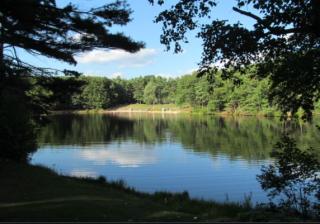
Paradise Pond: Long pond used for kayaking, skating, fishing, and ice fishing. There are trails around the back across a dam area on the south end. Parking off Route 31 both to the north and south of the pond.
Rocky Pond: An isolated pond along Rocky Pond/Parmenter Road, in the middle of the state forest.
Notown Reservoir: A large water body in the north end of LSF. Trails connect the Parmenter Road area with Notown Reservoir, and continue up to the Monoosnoc Trail.
Wolf Rocks: A rocky outcrop in the south part of the park, with a trail running over the top.