

Westminster - High Ridge WMA
HIKE NAME: High Ridge WMA DISTANCE: 4 Miles DIFFICULTY: Easy
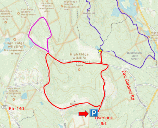
Trail Head: Westminster. There is a parking area just before the gate at the end of Overlook Road. https://maps.app.goo.gl/U83h1b1ifjVo5BzQ6
Difficulty and Distance: Easy-Moderate 3 mile
Hike Description: High Ridge is a Wildlife Management Area in north Westminster, near the Gardner line (up by the prison). While some of the trails are actually paved roads, the route goes through some pretty fields and nice forest, and there is a fine walk down to a large pond and dam.
Links: None
Hike Details: We chose to walk counter clockwise around the loop. It follows an old paved road through fields, and then curves down through the woods and along a brook, which can be a nice cascade when the water is running. There are bluebird nests along the way through the fields. The paved road goes down and around a corner and past the North Gardner Road trailhead and parking area, an alternative starting point.
Shortly after passing the parking area, there is a trail to the right that is worth taking out and back….it goes down to a dam and a large pond. There is also a pine grove with a small trail running around the perimeter...a nice option when conditions are dry. There are many trails on the other side of the dam, as the Wildlife Management Area continues over to Oakmont High School and along Whitmanville Reservoir.
The paved road then goes up a hill through a pretty forest, and at the top opens up into to a field. The gravel road continues straight, but to make the 4-mile loop you must turn left on a narrow trail through a small field. This turns into a wood trail skirts the Gardner prison grounds, and proceeds for about a half mile before reaching a gravel road where the route turns left again on a well-used path. Gunfire from the prison firing range can often be heard throughout this area.
From there the gravel road is lovely, going through large open fields with bluebird nests and chestnut trees, to return to the parking area.
Other Options to Consider
There are some other options at the far corner, where the path goes left…if you continue on there is another loop to the right (North and East) that can be walked to add a couple of miles to the hike.
Rev 1/24
Restrictions: All non motorized allowed