

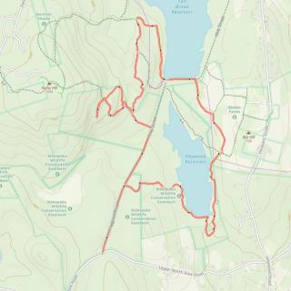
Sterling - Heywood Reservoir and Devils Pulpit
HIKE NAME: Sterling - Heywood Reservoir and Devil’s Pulpit DISTANCE: 4 Miles DIFFICULTY: Moderate
Restrictions: Hiking, snowshoeing and cross-country skiing are permitted. In season and with proper licenses, fishing and hunting are also allowed. Motorized vehicles are prohibited.
Trailhead: Sterling. Park in the Heywood Reservoir lot, which is on Upper North Row Road, about 1.2 miles from Justice Hill Road. https://maps.app.goo.gl/9wVNBp3WkTALvUeT6
Description: The Heywood Reservoir Trail traverses a portion of Wekepeke Watershed lands owned by the Town of Clinton in both Sterling and Leominster. The trail offers scenic vistas of the Heywood Reservoir, a lovely section along Heywood Brook and a short open meadow trail section near Sholan Farms. Distance is about 4 miles due to the hike up to Devil’s pulpit, which is a large boulder up on a surrounding hill. Elevation is around 450 ft.
Links: Maps from the Leominster Trail Stewards show the portion of the trail that is in Leominster. An annotated map and brochure for the Heywood Reservoir loop can be accessed on the Sterling Open Space Page here.
Hike Details: Follow Hapgood Road, an abandoned paved road, straight from the kiosk down to a spot where a trail goes off to the left, marked with trail sign #175. Turn left and proceed up the hill to trail signs #155 and then #145. At #145 there is an out and back option on the left that leads to a large painted rock known as Devils pulpit. The trail is rough and poorly marked, with yellow blazes. This is a good photo spot!
Return to the main trail and proceed to the north on a small trail until point #140, then meet the blue-blazed Monoosnoc trail and turn right to go to the Fall Brook Reservoir. Hike along the west side of the reservoir until reaching trail sign #160. Cross over the berm and enter a trail to the right that continues around Heywood Reservoir. This takes you out to a field, which must be crossed, and the path then heads down to the reservoir. Cross over a fairly steep hill and take the trail to the south to the dam.
A bit south of the dam there is a path down to the brook, which can be crossed in most seasons. Note that it often cannot be crossed in the winter! This small path winds back around to an open area along the reservoir, and then off through the woods and back to Hapgood Road.
A left turn on Hapgood Road leads to the parking area.
Other Options to Consider:
About half way along the trail on the east side of Heywood Reservoir there is a trail to the left leading through the field and Sholan Farms. There are several nice walking trails around the apple trees, and Sholan is an alternate parking place. The trail system can also be accessed In Leominster from Wachusett Street and May Street off of Pleasant St.
A challenging option is to scramble up to Rocky Hill from Devil’s pulpit and make a loop (purple line on map) over the hill to Fall Brook Reservoir. This is a steep trail (can be done in either direction). Rocky Hill has a number of transmitters, and the antennas can be seen from high points to the west (including the summit of Mt. Wachusett)
The hike can easily be shortened to three miles by skipping the Devil’s pulpit loop.
Historical Notes: A very interesting and complete history of the Wekepeke Watershed can be found here.
Rev 1/24
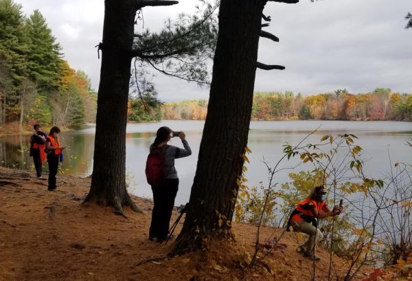
On the southwest shore of Heywood Reservoir

Princeton HIkers at Heywood Reservoir