

Four Corners
HIKE NAME: Four Corners Loop DISTANCE: 2.5 Miles DIFFICULTY: Easy
Restrictions: No motorized vehicles
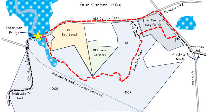
Trailhead: Princeton. At the kiosk just south of the Gates Road intersection with Thompson/Old Colony Road. There is parking at the edge of the field. https://goo.gl/maps/BTjVSFfnTvBEgjzV9
Hike Description: This is a lovely hike that includes open fields, woodland, road walking and a lovely view of the Ware River and watershed area. Total elevation gain is 200 feet.
Links: Four Corners Kiosk
Hike Details: The loop can be taken clockwise or counterclockwise. This description will follow the clockwise route. From the kiosk at Gates Road, take the trail across the field to the west. Follow the trail along the edge of the field, turning left and staying along the edge of the field. From this portion of the trail be sure to turn around to see the view of the windmills and Wachusett Mountain.
Enter the woods on the left of the field and follow the Midstate Trail’s yellow triangular blazes. The trail passes some vernal pools, a hemlock grove and mixed hardwood forest. The trail begins to follow the edge of the Ware River and comes out of the woods at a gravel road. Turn left and go to the bridge that crosses the Ware river. There are wonderful views of the wetlands and marsh to the north as well as the river to the south of the bridge.
From the bridge, head back to the east along the gravel road. This eventually turns into a quiet, paved road, Old Colony Road. Take Old Colony to the intersection with Gates Road (note the historical marker at the crossroads). Turn right onto Gates Rd, and back to the parking area.
Other Options to Consider:
From the bridge over the Ware river an additional loop can be added that follows some quiet roads. Head briefly west and then follow the road to the south along the river, over the railroad tracks and past some houses. Continue straight on the paved road rather than cross the bridge to Route. 62. The paved road turns to the right and passes some swampy land on the left and forest until it ends at Lamphere Road in Hubbardston. Turning right and Lamphere Road will reconnect you with Old Colony Road at the Ware River Bridge.
Another option is to follow Old Colony Road crossing the Ware river at Route 62/Hubbardston Road. Follow the Midstate Trail across Route 62 and up the hill on Old Colony Road extension where the Midstate Trail continues into the Savage Hill Wildlife Management Area.
Another hiking option is to walk south along Gates Road from the kiosk, following the Midstate Trail yellow triangle blazes. Turn left onto Goodnow Road, which is an unpaved closed town road that leads to part of the Wachusett Meadow Audubon Sanctuary where there are many trails to explore.
In addition, there is an informal trail that connects the Midstate Trail to Old Colony Road just after you enter the woods from the field. This route can be used to avoid road walking around the corner from Old Colony Road onto Gates Road, where car traffic can be busy at times.
Historical Notes:
This land was conserved in the early 2000s by a group that included the Town of Princeton, Princeton Land Trust, Mass Audubon, DCR, and others. The 168-acre total lot has been largely left undeveloped, with fields retained for farming by the town and leased to a local farmer.
Long closed to car traffic, Goodnow Road was once a route for stagecoaches on their way from Templeton to Boston. Large stone walls on both sides of the road and many impressive birch trees can be seen along the route.
Rev: 12/6/23
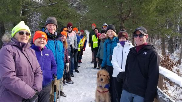
Princeton Hikers at the bridge over the East Branch of the Ware River
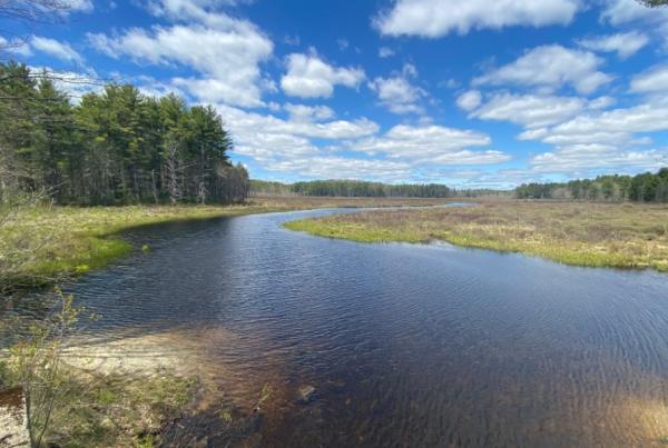
View from the bridge over the East branch of the Ware River