

Sterling - Clinton Dam and Tunnel
HIKE NAME: Sterling - Clinton Dam and Tunnel DISTANCE: 3-7 Miles DIFFICULTY: Easy-Moderate
Restrictions: No motorized vehicles, no dogs.
Trailhead: Sterling. The parking area is on route 110 in Sterling, about a quarter mile north of Chace Hill Road. Parking is available on both sides of the road. https://maps.app.goo.gl/Ns9sP8Mq7rpe95zL6
Hike Description: This is a walk along the North Dike of the Wachusett Reservoir, over to the large dam in Clinton. For those who are up for a challenge, the hike continues across the dam area and over to an abandoned train tunnel on the east side of route 70.
This hike can be done with two levels of difficulty. Some hikers park cars at the dam end, and carpool back to the start of the hike, then simply walk the 3 miles to the dam. Others do a round-trip and also include the walk down to the tunnel, which is approximately 7 miles. To cross the dam area, there is a hike down to the bottom of the dam area and back up (with about 200 steps on each side!)
This is a really nice walk in good weather. Because the area is open and exposed,it can be less fun on a wet or windy day. The trail is similar to a flat rail trail with one slight climb through a woody area halfway between the trailhead and the dam.
Total elevation is 200 feet if crossing the dam area.
Links: None
Hike Details:
Start in West Sterling at the trailhead on Route 110 near the North Dike of the Wachusett Reservoir. The start of the hike travels along the north dike, which runs right along the water and is a wide grassy walk in the open with very pretty views out to Wachusett Reservoir. This path goes past the high school, through a railway cut, and out to the Clinton Dam by the sluiceway – an impressive sight, particularly when water is high!
At that point hikers have two options. The more difficult way forward is down the 200 steps to the bottom of the dam and then back up the 200 steps to the east side. However, there is an easier path to the bottom, and cars may be parked at the bottom to ferry people back up to the east side.
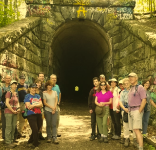
From the east side of the dam, on Route 70, walk down the hill on the sidewalk for less than a quarter mile to the railroad tunnel on the east side of Route 70. Walk up the embankment to the tunnel and through the tunnel (using headlamps) to the other side. A very interesting walk!!
Return via the same path.
Other Options to Consider:
The hike can also be done from the Clinton schools area, which eliminates about a mile from the walk, but also eliminates the best part of the North Dike walk.
There are some trails on the far side of the tunnel by the Raucher Farm. This is a nice area to explore, but the trail just past the tunnel is difficult. There is work planned to improve this connection.
Historical Notes:
Rev 1/24
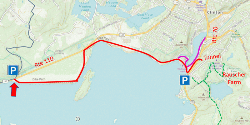
Map showing the hike along the North Dike of Wachusett Reservoir to CLinton Dam and Tunnel
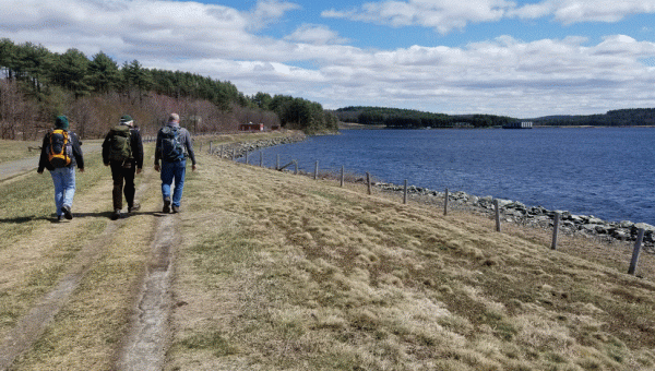
Walking along the North Dike