Bickford Pond Loop
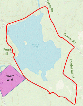
HIKE NAME: Bickford Pond Loop DISTANCE: 3.5 Miles DIFFICULTY: Easy to Moderate
Restrictions: No motorized vehicles. Because this area is part of the watershed, certain activities are restricted.
Trailhead: Princeton. Park at the corner of Rhodes and Green Roads in Northwest Princeton. https://goo.gl/maps/NyqKSxCwhF6zo8ZPA
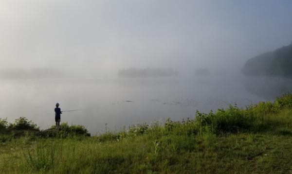
Description: Bickford Pond is a 163 acre reservoir, half of which resides in Princeton and half in Hubbardston. The East Branch of the Ware River and the West Wachusett Brook flow into the pond. This walk takes you from the Green Road extension, a discontinued portion of the road, to a trail that loops around the entire pond, then back along Rhodes Road.
Links: None
Hike Details: Start at the corner of Rhodes and Green Roads in Princeton. Walk out Green Road (discontinued dirt road) into Hubbardston. This is a rough road where Fitchburg Water has recently replaced the culvert.
Just before crossing the Westminster line onto Lanes Road there is a gate on the left. Go through the gate and down the hill to the stream that connects Bickford Pond to Mare Meadow. This stream can be broad and deep at times of high water (typically in the winter and spring) and may not be easily crossable. If you can continue, cross the stream and continue on the paved road until you see an open berm heading to the left, on the west side of the pond.
Cross the berm, which provides a beautiful view of Mt Wachusett, and bear to the right and past a large rock to take a trail up and over the hill to the dam with a steep descent at the end to the dam. This is another spot with great views to the east of Wachusett Mountain, and also down the spillway to the East Branch of the Ware River.
Cross the dam and continue on a bushwack up through the woods to avoid private property shown on the map. This short bushwhack must avoid crossing the stone wall closest to the AT+T line. When you reach the AT+T line, turn left and continue along that track, which is often wet (pass on the right). There are three bypass trails marked by yellow blazes (two on the right and one on the left). After the third bypass, the trail bears to the right and exits through the Zinns Conservation Area. After the gate, turn left on Rhodes Road and continue to the starting point.
Other Options to Consider: When water is high in the spring, or after heavy rains, the stream at the north end of the pond will be too wide to cross and it is better to walk down Rhodes Road and out and back through Zins Conservation Area rather than walking the loop. You can check out this crossing from the Westminster side at the end of Lanes Road.
Historical Notes: Bickford Pond Dam, which was built in 1970, is a 933-foot long earth dam with concrete core wall. Fitchburg gets its drinking water from Mare Meadow Reservoir and has access to Bickford Pond as an emergency backup supply. According to Fitchburg’s 2002 DEP Source Water Protection Report, the city’s population grew rapidly between 1907 and 1930 and, due to periodic drought conditions, Mare Meadow Reservoir and Bickford Pond were added to the system. Bickford Pond has never been used as a public water supply and Mare Meadow Reservoir is used approximately four to six weeks annually during periods of high demand.
Rev. 12/4/23
|